MERCATOR/HONDIUS, Daniae Regnum, 1630.
This auction is closed, but maybe you like the following items?

Images
Description
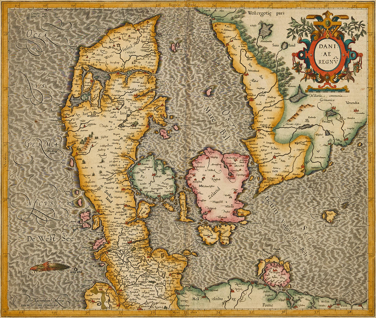
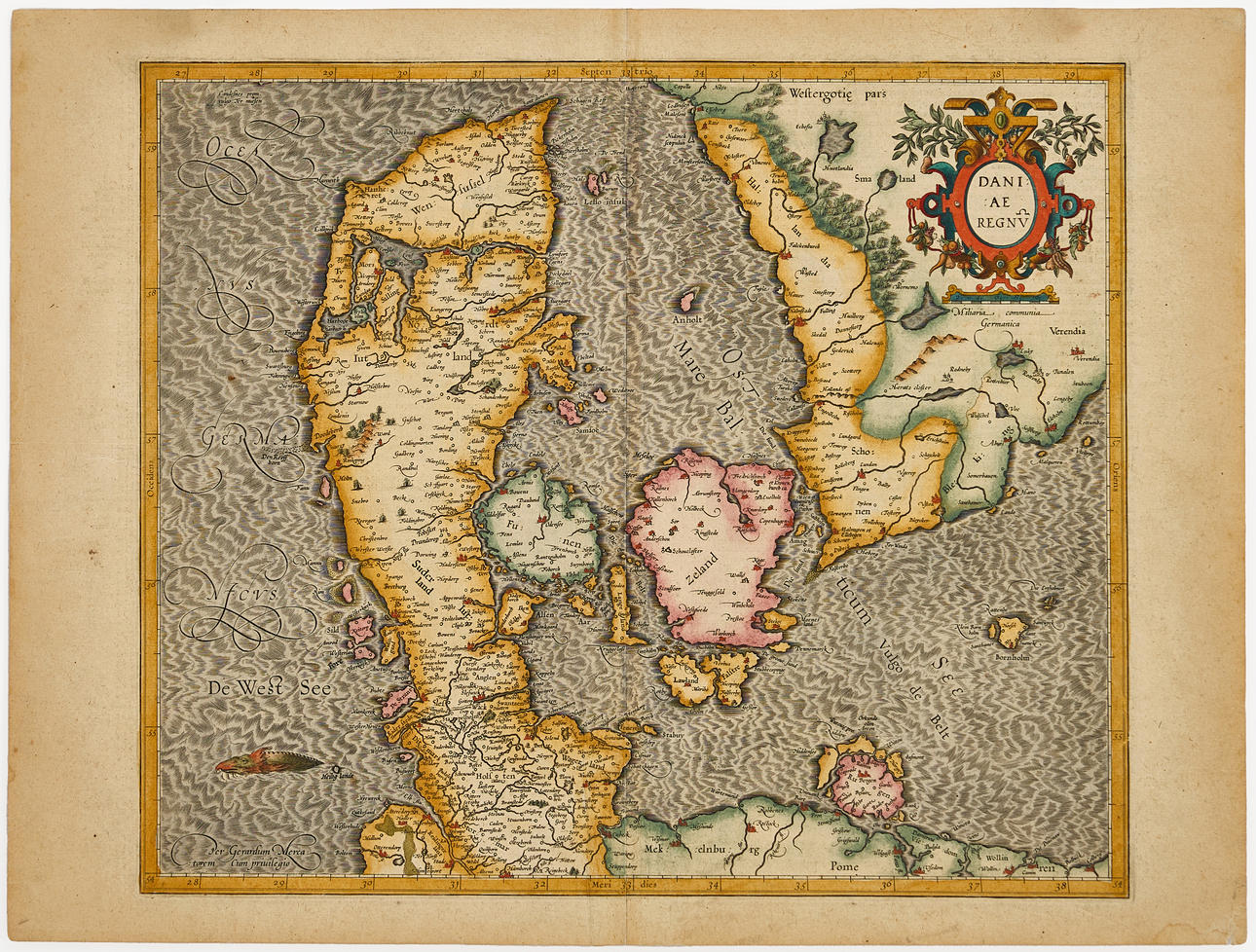
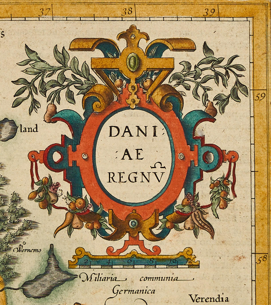
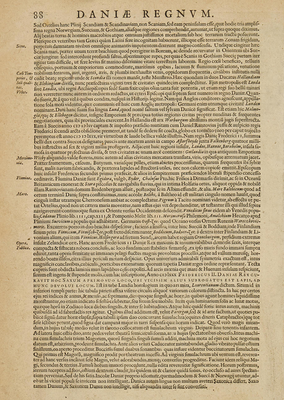
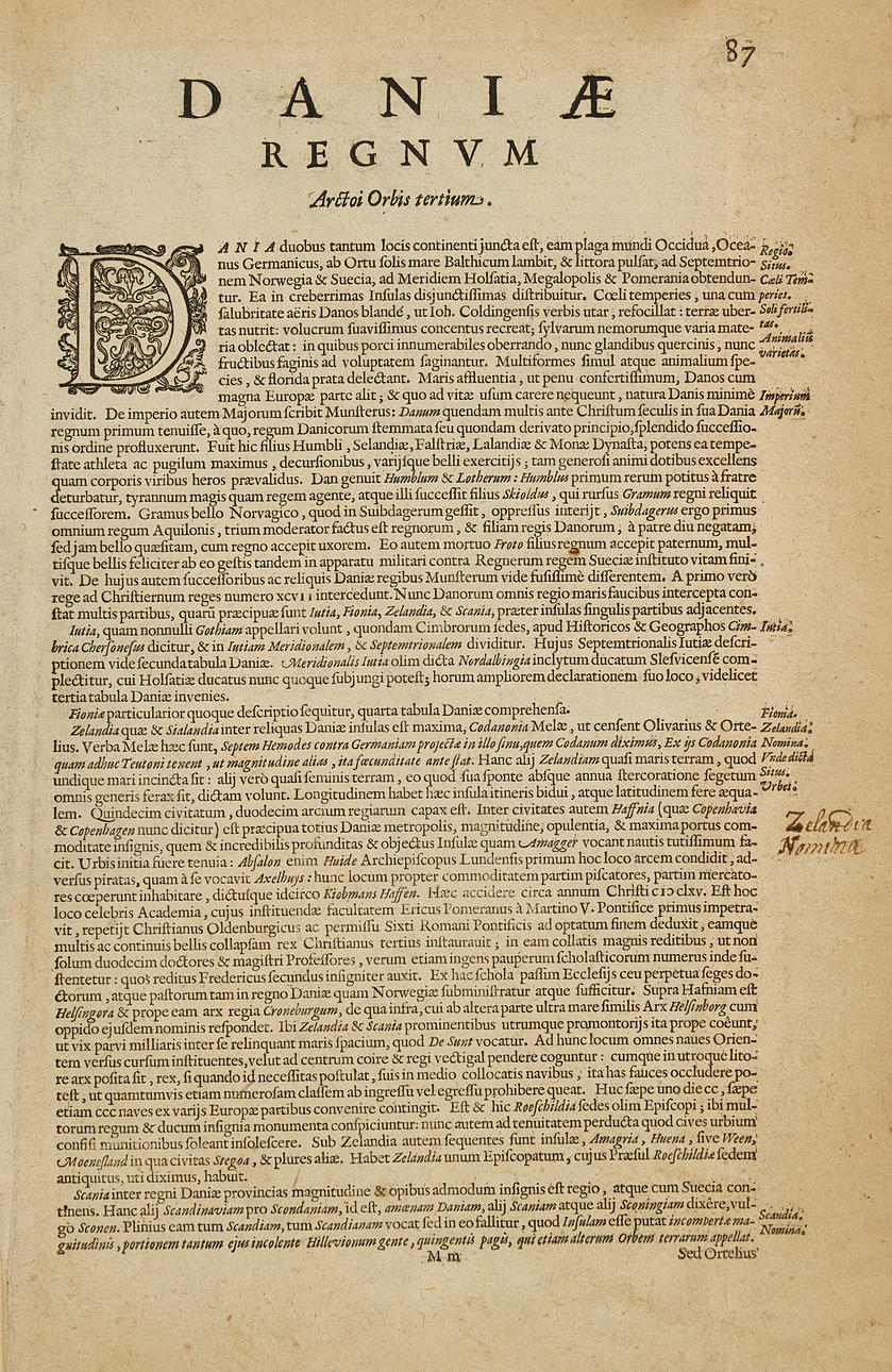
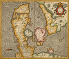
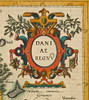
Gerhard Mercator (1512-1594) /Jodocus Hondius (1563-1612) /Hendrik Hondius (1596/97-1651), "Daniae Regnum", from the Mercator-Hondius Atlas, engraved and hand-coloured map of Denmark 1630, Latin text.
Plate: 37.8 x 44.5 cm.
Sheet: approx. 42 x 55.4 cm.
LITERATURE: Koeman 1500:1A.1.
The Hondius family business was founded by Jodocus Hondius (I, the Elder, 1563-1612), one of the most renowned engravers of his time. He is known for his collaborations with several prominent cartographers and publishers at the end of the 16th century and the beginning of the 17th century. He grew up in Ghent and apprenticed as an instrument maker, map engraver, and globe maker. In 1584, he fled the religious unrest sweeping through the Low Countries and stayed for a few years in London. Around 1593, he returned to establish himself in Amsterdam. During his years in London, he came into contact with leading scientists and geographers. He engraved maps for "The Mariner's Mirrour", the English edition of Waghenaer's sea atlas. Undoubtedly, his time in London helped provide him with an important network and international reputation. In 1604, Hondius purchased the plates for Mercator's Atlas, which, despite its quality, had never managed to compete with the constant demand for Ortelius' "Theatrum Orbis Terrarum". To make Mercator's Atlas more competitive, Hondius added approximately 40 additional maps. From 1606, the expanded edition was published in several languages, still under Mercator's name, but with his own name as publisher. These editions have become known as the Mercator/Hondius Atlas, and the maps were also re-engraved in a smaller format and published as "Atlas Minor".
After the death of Jodocus Hondius the Elder in 1612, work on the two atlases (folio and minor) was continued by his two sons Jodocus Hondius (II, 1594-1629) and Henricus Hondius (1597-1651), and from 1628 also in collaboration with Johannes Janssonius (1588-1664). In total, nearly 50 different editions were published from 1606 onwards, with an increasing number of maps, and in several European languages.
Condition
Yellowed, some spots. Damage to the lower right corner. Small tear (5 mm) on the left edge of the sheet, and a tear (15 mm) along the upper center fold/margin. Faint discolouration along the center fold, and creases on the sides along the center fold. A hole to the right of the title cartouche.
Unframed.
Theme
Francesco Bacoccoli Collection - The Golden Era of Cartography: Part II
Do you have something similar to sell? Get your items valued free of charge!
Description
Gerhard Mercator (1512-1594) /Jodocus Hondius (1563-1612) /Hendrik Hondius (1596/97-1651), "Daniae Regnum", from the Mercator-Hondius Atlas, engraved and hand-coloured map of Denmark 1630, Latin text.
Plate: 37.8 x 44.5 cm.
Sheet: approx. 42 x 55.4 cm.
LITERATURE: Koeman 1500:1A.1.
The Hondius family business was founded by Jodocus Hondius (I, the Elder, 1563-1612), one of the most renowned engravers of his time. He is known for his collaborations with several prominent cartographers and publishers at the end of the 16th century and the beginning of the 17th century. He grew up in Ghent and apprenticed as an instrument maker, map engraver, and globe maker. In 1584, he fled the religious unrest sweeping through the Low Countries and stayed for a few years in London. Around 1593, he returned to establish himself in Amsterdam. During his years in London, he came into contact with leading scientists and geographers. He engraved maps for "The Mariner's Mirrour", the English edition of Waghenaer's sea atlas. Undoubtedly, his time in London helped provide him with an important network and international reputation. In 1604, Hondius purchased the plates for Mercator's Atlas, which, despite its quality, had never managed to compete with the constant demand for Ortelius' "Theatrum Orbis Terrarum". To make Mercator's Atlas more competitive, Hondius added approximately 40 additional maps. From 1606, the expanded edition was published in several languages, still under Mercator's name, but with his own name as publisher. These editions have become known as the Mercator/Hondius Atlas, and the maps were also re-engraved in a smaller format and published as "Atlas Minor".
After the death of Jodocus Hondius the Elder in 1612, work on the two atlases (folio and minor) was continued by his two sons Jodocus Hondius (II, 1594-1629) and Henricus Hondius (1597-1651), and from 1628 also in collaboration with Johannes Janssonius (1588-1664). In total, nearly 50 different editions were published from 1606 onwards, with an increasing number of maps, and in several European languages.
Condition
Yellowed, some spots. Damage to the lower right corner. Small tear (5 mm) on the left edge of the sheet, and a tear (15 mm) along the upper center fold/margin. Faint discolouration along the center fold, and creases on the sides along the center fold. A hole to the right of the title cartouche.
Unframed.
Theme
Francesco Bacoccoli Collection - The Golden Era of Cartography: Part II
Do you have something similar to sell? Get your items valued free of charge!