HOMANN (HEIRS), “Florentiæ”, 1731.
This auction is closed, but maybe you like the following items?

Images


Description
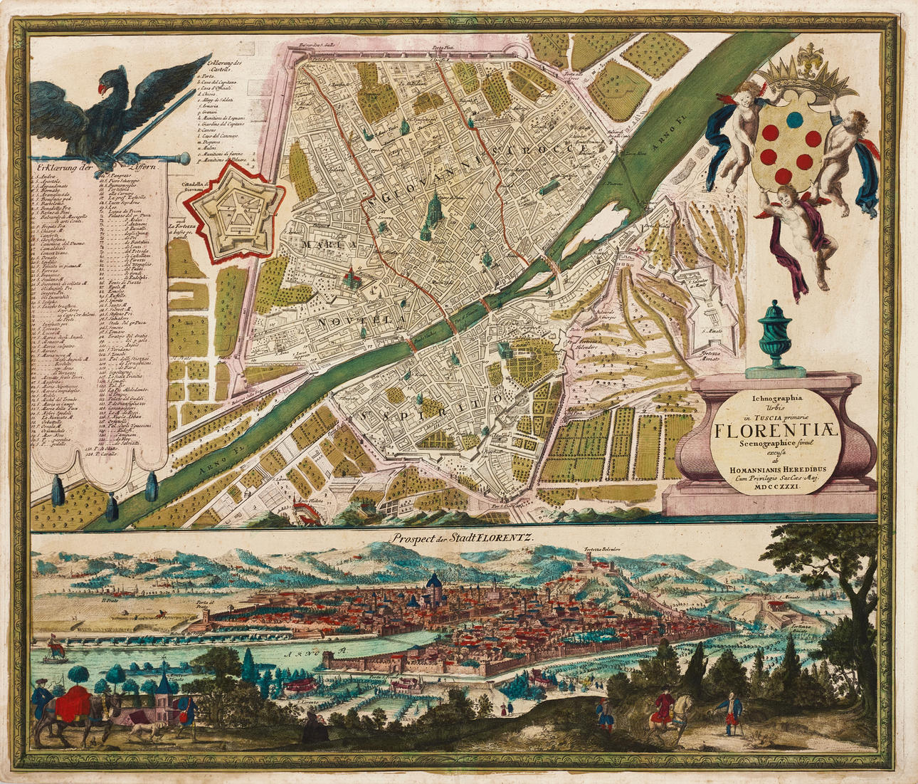
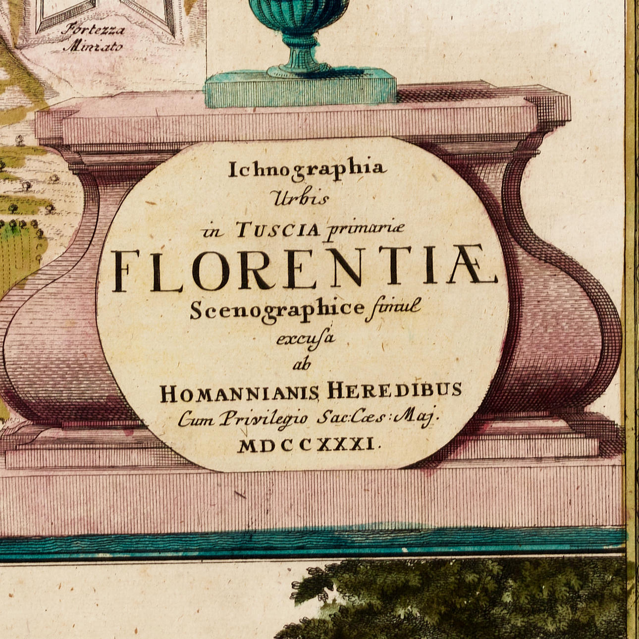
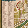
Johann Baptista Homann (Heirs), “Ichonographia Urbis in Tuscia primariæ Florentiæ Scenographice... “, engraved and hand-colored map and city view of Florence, 1731.
Plate: 49,5 x 58,4 cm.
Leaf: 51.2 x 59.5 cm.
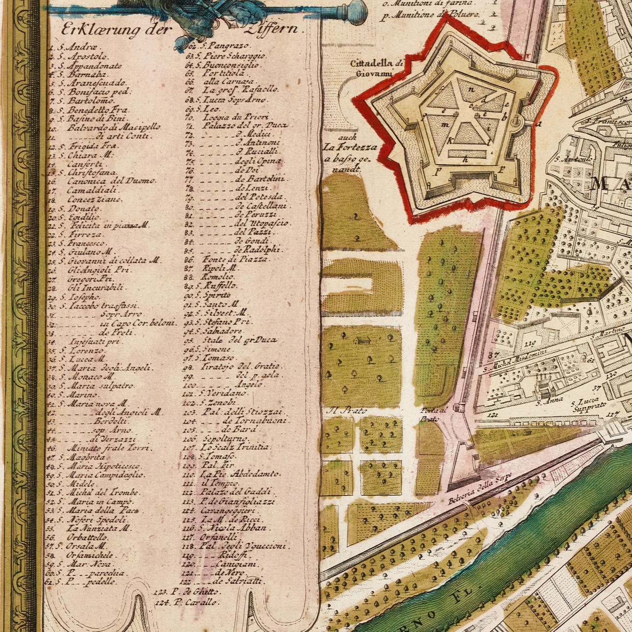
Detailed map of Florence divided into four different districts: Maria Novella, Sa. Giovanni and Sa. Crocce on one side of the River Arno, and St. Spirito on the other side. Central to the map is the Basilica di Santa Maria del Fiore with Brunelleschi's famous dome. On the left a cartouche with a list of 124 place-names, and on the right the title cartouche and in the upper left corner the coat of arms of the Grand Duchy of Tuscany borne by three amorines. At the bottom is the abundantly coloured view of Florence (“Prospect der Stadt Florentz”), seen towards the Cathedral and the Fortezza Belvedere.
The Homann family was one of Germany's most important publishers of maps during the 18th century, and with a leading role in the European map market. The firm was founded in 1702 by Johann Baptista Homann (c. 1663-1724), and passed on his death to his son Johann Christopher (1703-1730). When he passed away at the age of only 27, the company passed to his heirs, with the proviso that they continued the business under the name “Homann heirs” (Homannischen Erben, Homanniani Heredes, or Héritiers de Homann). The heirs included Johann Michael Franz, Johann Mattias Hase, Johann Georg Ebersperger and others. Through various purchases, the Homann business was eventually acquired by Georg Christoph Franz Fembo (1781-1848), and on his death the business was closed down. Johann Baptista Homann's more famous works include Atlas Novus Terrarum (1702, reissued 1753), Neuer Atlas (1707-1730), Atlas Methodicus (1719), America Septentionali Britannorum (1730), Atlas Minor (1732), Grosser Atlas ueber die ganze Welt (1716-1770), as well as many different individual maps.
Condition
Yellowed, spots. Small defects along the edges of the leaf.
Not framed.
Theme
Francesco Bacoccoli Collection - The Golden Era of Cartography: Part I
Do you have something similar to sell? Get your items valued free of charge!
Description
Johann Baptista Homann (Heirs), “Ichonographia Urbis in Tuscia primariæ Florentiæ Scenographice... “, engraved and hand-colored map and city view of Florence, 1731.
Plate: 49,5 x 58,4 cm.
Leaf: 51.2 x 59.5 cm.
Detailed map of Florence divided into four different districts: Maria Novella, Sa. Giovanni and Sa. Crocce on one side of the River Arno, and St. Spirito on the other side. Central to the map is the Basilica di Santa Maria del Fiore with Brunelleschi's famous dome. On the left a cartouche with a list of 124 place-names, and on the right the title cartouche and in the upper left corner the coat of arms of the Grand Duchy of Tuscany borne by three amorines. At the bottom is the abundantly coloured view of Florence (“Prospect der Stadt Florentz”), seen towards the Cathedral and the Fortezza Belvedere.
The Homann family was one of Germany's most important publishers of maps during the 18th century, and with a leading role in the European map market. The firm was founded in 1702 by Johann Baptista Homann (c. 1663-1724), and passed on his death to his son Johann Christopher (1703-1730). When he passed away at the age of only 27, the company passed to his heirs, with the proviso that they continued the business under the name “Homann heirs” (Homannischen Erben, Homanniani Heredes, or Héritiers de Homann). The heirs included Johann Michael Franz, Johann Mattias Hase, Johann Georg Ebersperger and others. Through various purchases, the Homann business was eventually acquired by Georg Christoph Franz Fembo (1781-1848), and on his death the business was closed down. Johann Baptista Homann's more famous works include Atlas Novus Terrarum (1702, reissued 1753), Neuer Atlas (1707-1730), Atlas Methodicus (1719), America Septentionali Britannorum (1730), Atlas Minor (1732), Grosser Atlas ueber die ganze Welt (1716-1770), as well as many different individual maps.
Condition
Yellowed, spots. Small defects along the edges of the leaf.
Not framed.
Theme
Francesco Bacoccoli Collection - The Golden Era of Cartography: Part I
Do you have something similar to sell? Get your items valued free of charge!