ORTELIUS, Namurcum, Comitatus, 1592.

Images
Description
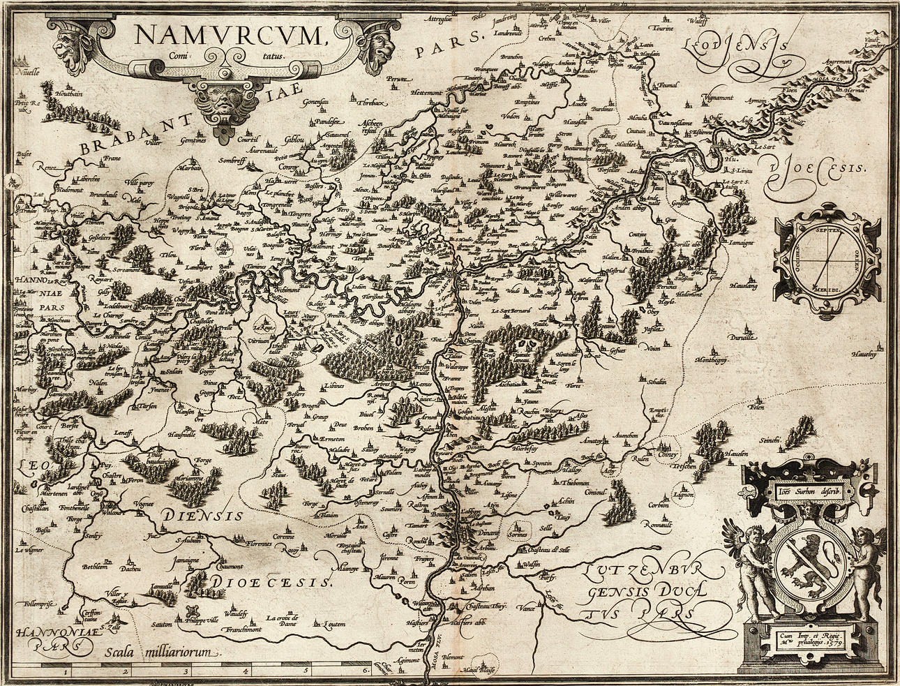
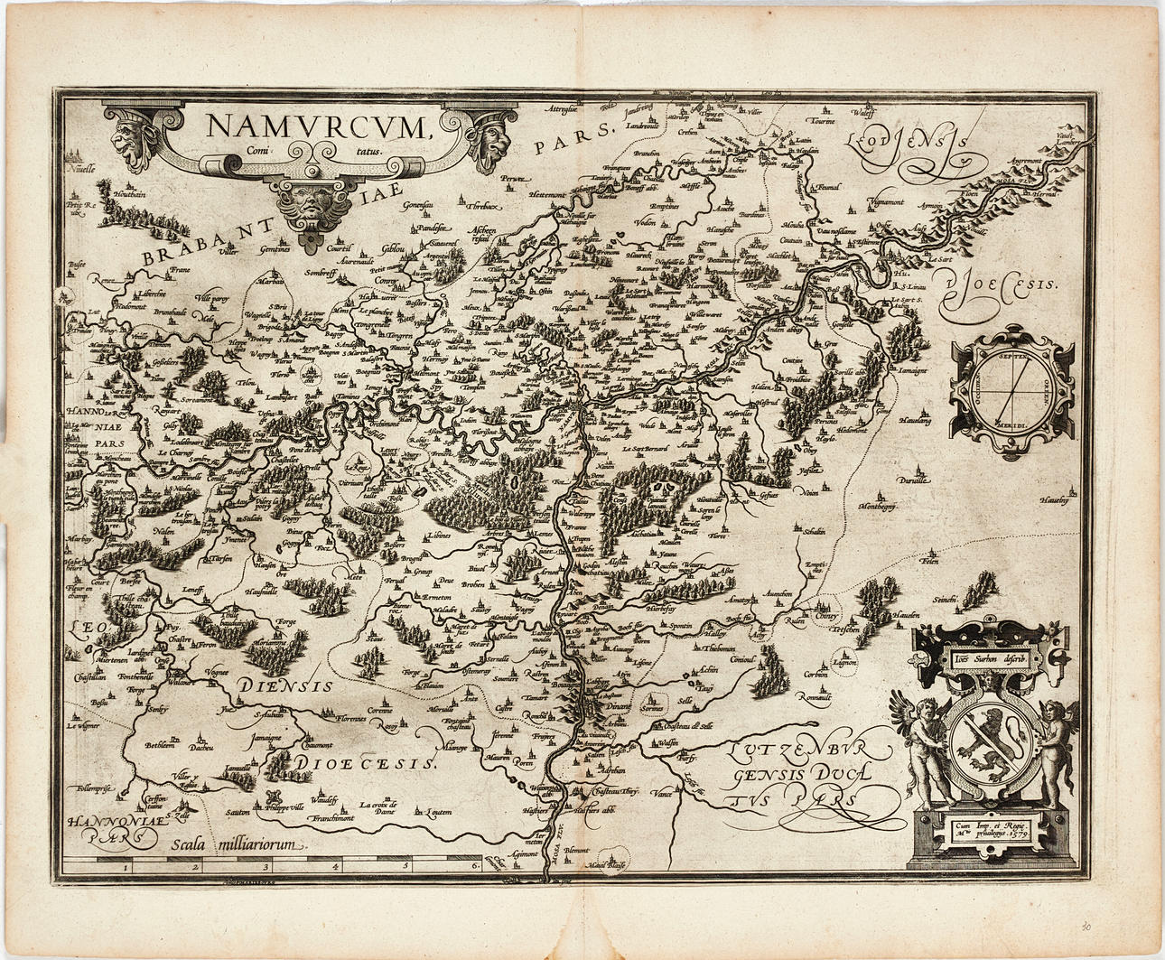
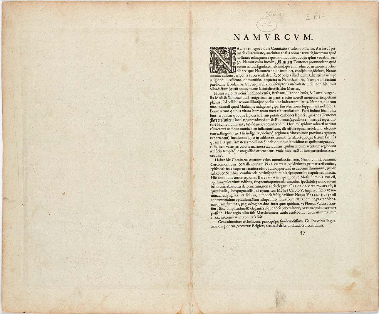
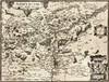
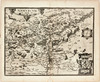
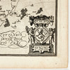
Abraham Ortelius (1527-1598), "Namurcum, Comitatus.", engraved and hand-coloured map of the County of Namur. Latin edition 1592 (1592L37, 500 copies).
Plate: 33.7 x 51.3 cm.
Sheet: approx. 47 x 56.8 cm (unidentified watermark, coat of arms).
LITERATURE: Van den Broecke, Ort 68.
Koeman/Meurer 80
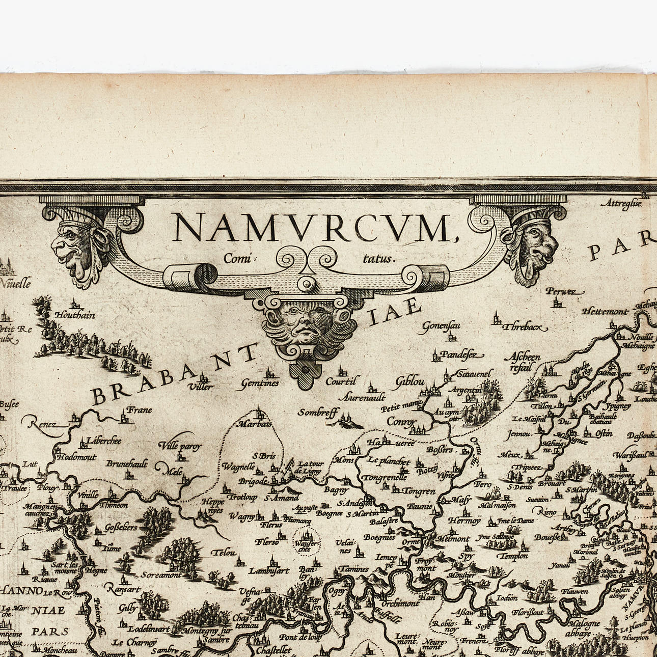
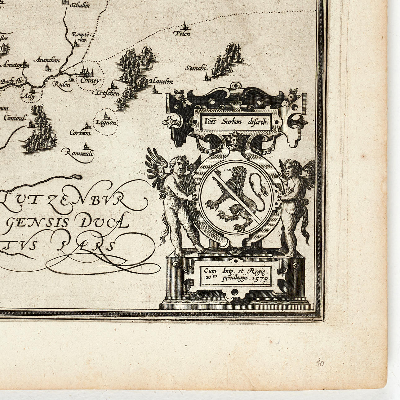
With title cartouche in the upper left corner, and an additional cartouche in the lower right corner with the coat of arms of Namur and the name of the cartographer Jacques Surhon, as well as with privilege.
Jacques Surhon drew a map of Luxembourg in 1555, but it was not published for security reasons. It was not until 1579, when Antwerp was independent for a short period, that Ortelius made use of it (Meurer, pp. 251-252).
Abraham Ortelius (1527-1598) was born in Antwerp and studied Greek and Latin as well as mathematics. Together with his sisters Anne and Elisabeth, he coloured maps, but also dealt in antiquities, coins, books, and maps. His business grew, as did his network of contacts with the scientists and publishers of the time, which was also facilitated by the many journeys he undertook in Europe.
In 1564, he published his first map, a world map that today has survived in only a handful of copies. In 1565, a map of Egypt and the Holy Land, as well as a map of Asia. By 1568, the production of individual maps for his atlas "Theatrum Orbis Terrarum" was in full swing, and the following year, 1569, the atlas was completed. In May 1570, it was offered for sale to interested buyers and was one of the most expensive books ever published. The first edition consisted of 70 maps printed on 53 sheets, and engraved by Frans Hogenberg. It became extremely sought after and about 24 editions were published during Ortelius's lifetime, and thereafter a further 10 editions in six different languages until 1612; the atlas also grew in the number of maps and pages as new editions were published. The importance of Ortelius's atlas for the late 16th-century understanding of the world and geographical knowledge cannot be overstated. Today, one often speaks of Ortelius's atlas when referring to "Theatrum Orbis Terrarum"; however, the term atlas itself was only introduced over 20 years later by Mercator, but Ortelius was the one who, in a true sense, created the first modern atlas.
Condition
Yellowed. Damp stain in the lower margin, and partially in the image (at the center fold). Some minor spots. Faint discolouration along the center fold.
Not framed.
Theme
Francesco Bacoccoli Collection - The Golden Era of Cartography: Part II
Description
Abraham Ortelius (1527-1598), "Namurcum, Comitatus.", engraved and hand-coloured map of the County of Namur. Latin edition 1592 (1592L37, 500 copies).
Plate: 33.7 x 51.3 cm.
Sheet: approx. 47 x 56.8 cm (unidentified watermark, coat of arms).
LITERATURE: Van den Broecke, Ort 68.
Koeman/Meurer 80
With title cartouche in the upper left corner, and an additional cartouche in the lower right corner with the coat of arms of Namur and the name of the cartographer Jacques Surhon, as well as with privilege.
Jacques Surhon drew a map of Luxembourg in 1555, but it was not published for security reasons. It was not until 1579, when Antwerp was independent for a short period, that Ortelius made use of it (Meurer, pp. 251-252).
Abraham Ortelius (1527-1598) was born in Antwerp and studied Greek and Latin as well as mathematics. Together with his sisters Anne and Elisabeth, he coloured maps, but also dealt in antiquities, coins, books, and maps. His business grew, as did his network of contacts with the scientists and publishers of the time, which was also facilitated by the many journeys he undertook in Europe.
In 1564, he published his first map, a world map that today has survived in only a handful of copies. In 1565, a map of Egypt and the Holy Land, as well as a map of Asia. By 1568, the production of individual maps for his atlas "Theatrum Orbis Terrarum" was in full swing, and the following year, 1569, the atlas was completed. In May 1570, it was offered for sale to interested buyers and was one of the most expensive books ever published. The first edition consisted of 70 maps printed on 53 sheets, and engraved by Frans Hogenberg. It became extremely sought after and about 24 editions were published during Ortelius's lifetime, and thereafter a further 10 editions in six different languages until 1612; the atlas also grew in the number of maps and pages as new editions were published. The importance of Ortelius's atlas for the late 16th-century understanding of the world and geographical knowledge cannot be overstated. Today, one often speaks of Ortelius's atlas when referring to "Theatrum Orbis Terrarum"; however, the term atlas itself was only introduced over 20 years later by Mercator, but Ortelius was the one who, in a true sense, created the first modern atlas.
Condition
Yellowed. Damp stain in the lower margin, and partially in the image (at the center fold). Some minor spots. Faint discolouration along the center fold.
Not framed.
Theme
Francesco Bacoccoli Collection - The Golden Era of Cartography: Part II
Payment options for this item
Payment cardsBank transferDelivery
: Provide your locationInfo temporarily unavailableLoading…Provide your location to see transport options and prices.
Oops! Something went wrong.
Please try again in a moment. If it still doesn't work, contact Auctionet support.
Details
- Address
Galoppvägen 3
183 64 Täby
Sweden- Placement
- Vagga Bacoccoli Stor