ORTELIUS, Portugalliae, 1603.
This auction is closed, but maybe you like the following items?

Images
Description
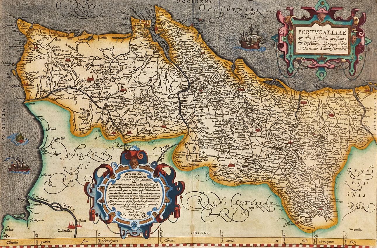
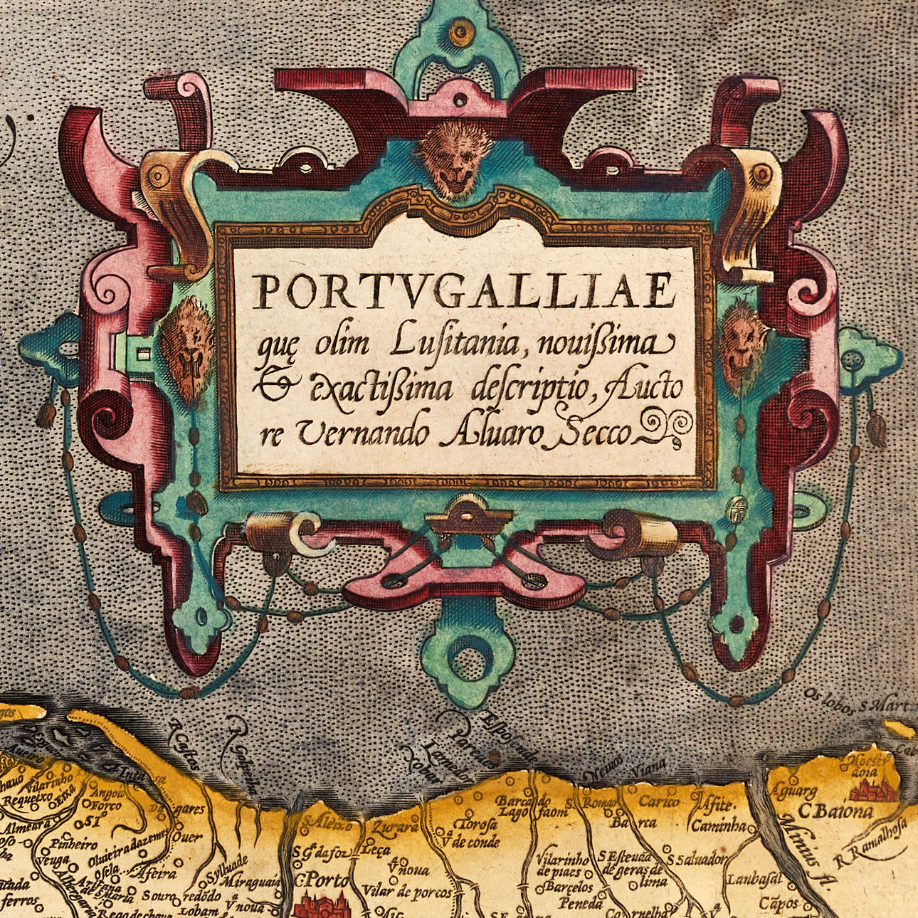
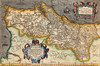
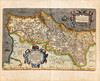
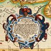
Abraham Ortelius (1527-1598), “Portugalliae quo olim Lusitania, novissima & exactissima descriptio, Auctore Vernando Aluaro Secco”, engraved and hand-coloured map of Portugal, from Ortelius's “Theatrum Orbis Terrarum”. Latin edition 1603 (1603L17, 300 copies).
Plate: 34.2 x 51 cm.
Blade: 45 x 55.3 cm (unidentified watermark, shield)
LITERATURE: Van den Broecke, City 26.
Koeman/Meurer 8.
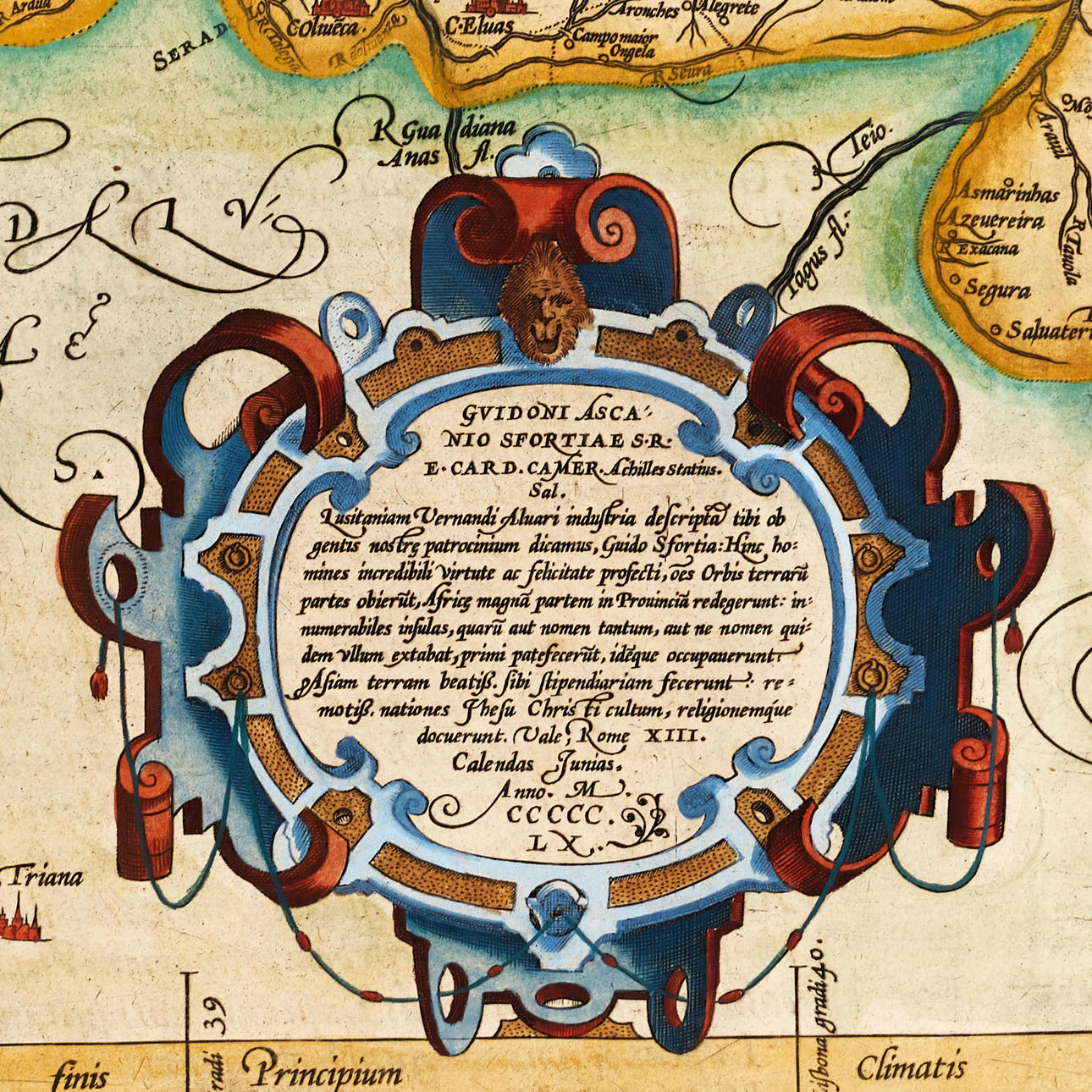
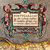
The map with large title cartouche in the upper right corner, two ships, a sea monster and a large cartouche in the lower left [Achilles Statius salutes Guido Ascanius Sfortia, S.R.E. Card [inalis] Camer [arius] (eng translation): With dedication the Lusitania of Fernando Alvaro has been depicted for you, Guido Sfortia, because we call it the protectorate of our people: from here men have sailed out with incredible courage in foul and fair. They have frequented all parts of the world. Věrý. The most fair lands of Asia they have made tributaries; the most distant lands they taught the service and religion of Jesus Christ. Danger thee well. Rom, on the 13th day of the calendar of June, in the year 1560.
Abraham Ortelius (1527-1598) was born in Antwerp and came to study Greek and Latin as well as mathematics. Together with his sisters Anne and Elisabeth, he colourised maps, but also traded in antiques, coins, books and maps. His business grew and so did his network of contacts with the scientists and book publishers of the time, which was also facilitated by the many trips he undertook in Europe.
In 1564, he published his first map, a map of the world that has survived only in a handful of copies. 1565 saw a map of Egypt and the Holy Land, as well as a map of Asia. In 1568 the production of individual maps for his atlas “Theatrum Orbis Terrarum” was in full swing and the following year, 1569 the atlas was completed. In May 1570 it was put up for sale to squatted speculators and was one of the costliest books ever published. The first edition consisted of 70 maps printed on 53 leaf sheets, and engraved by Frans Hogenberg. It became in great demand and some 24 editions were published during Ortelius' lifetime, and then another 10 editions in six different languages until 1612, the atlas also grew in the number of maps and pages after which new editions were published. The importance of Ortelius's atlas for the late 16th century understanding of the world and geographical knowledge cannot be emphasized enough. Today, Ortelius's atlas is often spoken of when referring to the “Theatrum Orbis Terrarum”, the term atlas itself, however, was first introduced over 20 years later by Mercator, but Ortelius was the one who, in the truest sense, created the first modern atlas.
Condition
Yellowed, spots mainly at the margin. The middle fold with partially made/reinforced rips at the top and bottom (55mm). The right part of the blade with a long, retouched tear (220mm, with older repair on verso). The edges of the leaves with minor defects. A needle prick in the image surface.
Not framed.
Theme
Francesco Bacoccoli Collection - The Golden Era of Cartography: Part I
Do you have something similar to sell? Get your items valued free of charge!
Description
Abraham Ortelius (1527-1598), “Portugalliae quo olim Lusitania, novissima & exactissima descriptio, Auctore Vernando Aluaro Secco”, engraved and hand-coloured map of Portugal, from Ortelius's “Theatrum Orbis Terrarum”. Latin edition 1603 (1603L17, 300 copies).
Plate: 34.2 x 51 cm.
Blade: 45 x 55.3 cm (unidentified watermark, shield)
LITERATURE: Van den Broecke, City 26.
Koeman/Meurer 8.
The map with large title cartouche in the upper right corner, two ships, a sea monster and a large cartouche in the lower left [Achilles Statius salutes Guido Ascanius Sfortia, S.R.E. Card [inalis] Camer [arius] (eng translation): With dedication the Lusitania of Fernando Alvaro has been depicted for you, Guido Sfortia, because we call it the protectorate of our people: from here men have sailed out with incredible courage in foul and fair. They have frequented all parts of the world. Věrý. The most fair lands of Asia they have made tributaries; the most distant lands they taught the service and religion of Jesus Christ. Danger thee well. Rom, on the 13th day of the calendar of June, in the year 1560.
Abraham Ortelius (1527-1598) was born in Antwerp and came to study Greek and Latin as well as mathematics. Together with his sisters Anne and Elisabeth, he colourised maps, but also traded in antiques, coins, books and maps. His business grew and so did his network of contacts with the scientists and book publishers of the time, which was also facilitated by the many trips he undertook in Europe.
In 1564, he published his first map, a map of the world that has survived only in a handful of copies. 1565 saw a map of Egypt and the Holy Land, as well as a map of Asia. In 1568 the production of individual maps for his atlas “Theatrum Orbis Terrarum” was in full swing and the following year, 1569 the atlas was completed. In May 1570 it was put up for sale to squatted speculators and was one of the costliest books ever published. The first edition consisted of 70 maps printed on 53 leaf sheets, and engraved by Frans Hogenberg. It became in great demand and some 24 editions were published during Ortelius' lifetime, and then another 10 editions in six different languages until 1612, the atlas also grew in the number of maps and pages after which new editions were published. The importance of Ortelius's atlas for the late 16th century understanding of the world and geographical knowledge cannot be emphasized enough. Today, Ortelius's atlas is often spoken of when referring to the “Theatrum Orbis Terrarum”, the term atlas itself, however, was first introduced over 20 years later by Mercator, but Ortelius was the one who, in the truest sense, created the first modern atlas.
Condition
Yellowed, spots mainly at the margin. The middle fold with partially made/reinforced rips at the top and bottom (55mm). The right part of the blade with a long, retouched tear (220mm, with older repair on verso). The edges of the leaves with minor defects. A needle prick in the image surface.
Not framed.
Theme
Francesco Bacoccoli Collection - The Golden Era of Cartography: Part I
Do you have something similar to sell? Get your items valued free of charge!