ORTELIUS, Cypri Insulae Nova Descript., 1595.
This auction is closed, but maybe you like the following items?

Images
Description
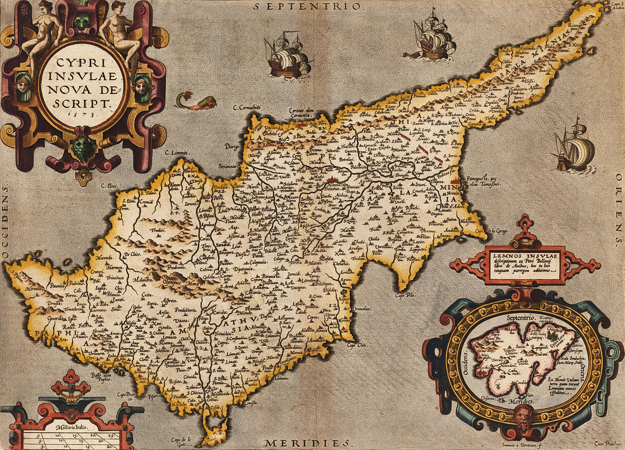
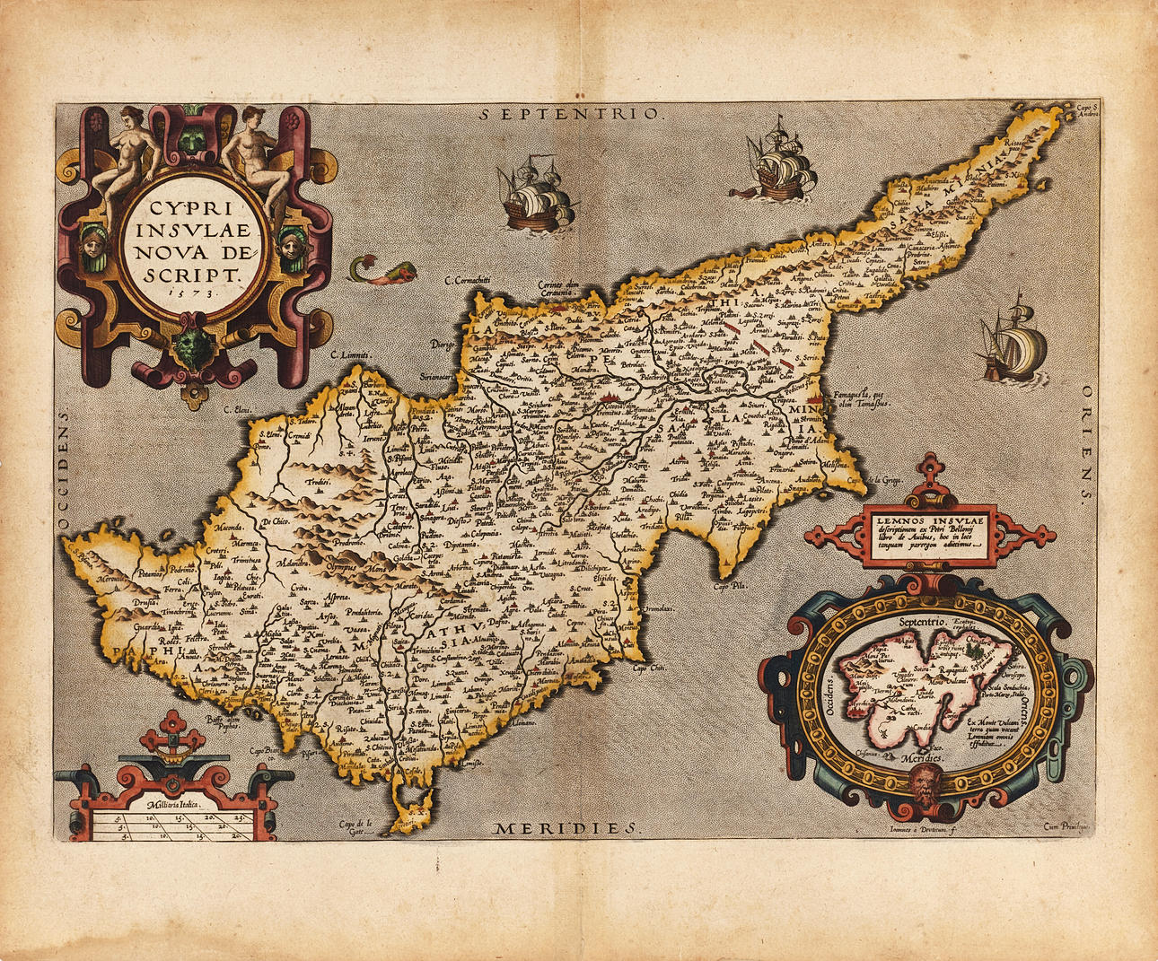
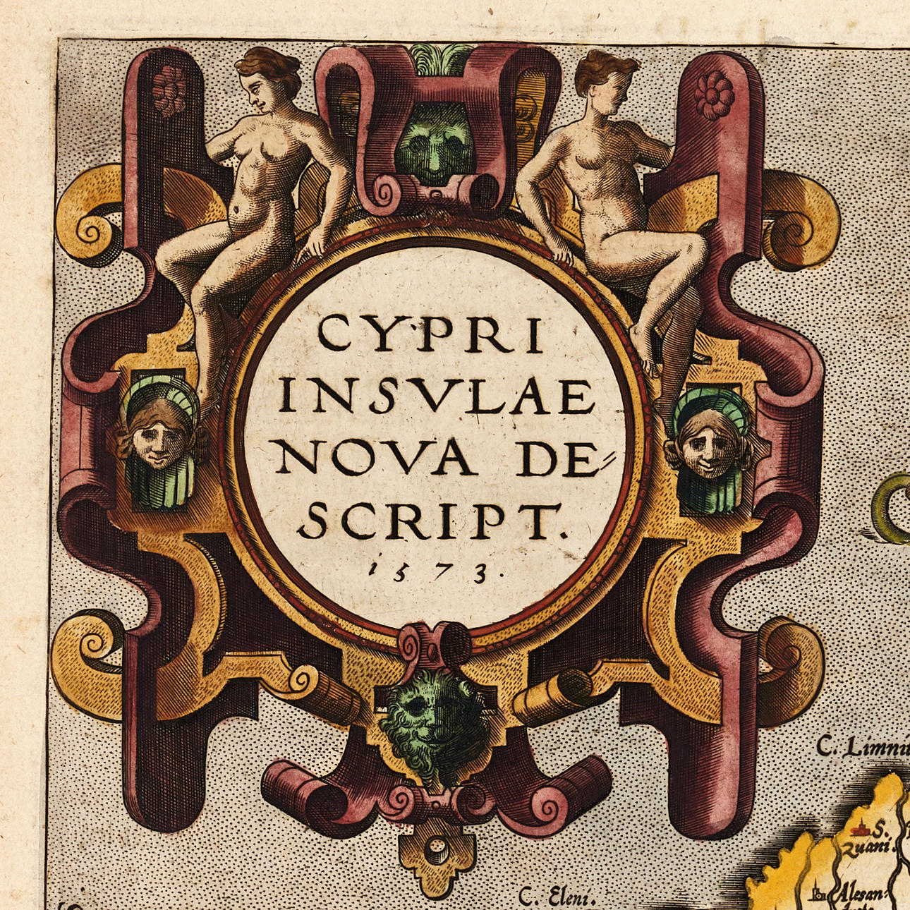
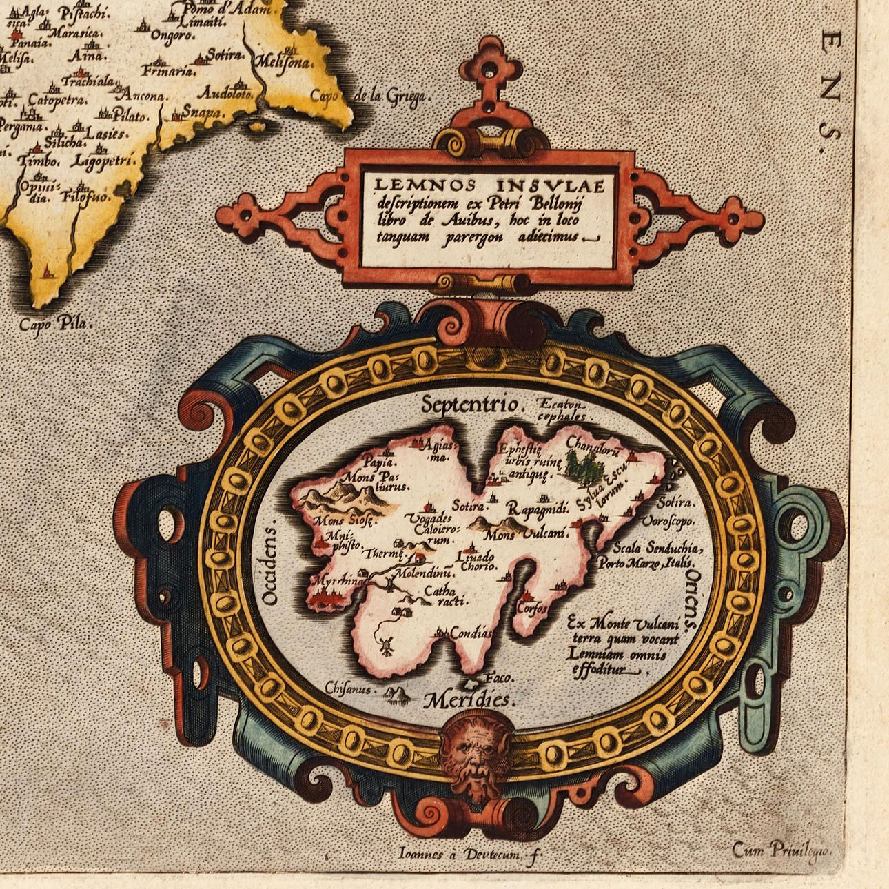
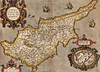
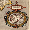
Abraham Ortelius (1527-1598), “Cypri Insulae Nova Descript. in 1573", engraved and hand-coloured map of Cyprus and Lemnos, from Ortelius's “Theatrum Orbis Terrarum”. Latin edition 1595 (1595L90, 500 copies).
Plate: 35 x 49,5 cm.
Leaf: 46.2 x 55.8 cm.
LITERATURE: Van den Broecke, City 149.
Koeman/Meurer 66.
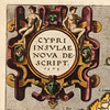
Early map of Cyprus, drawn by the Venetian engraver and publisher Giacomo Franco (1550-ca 1620) and engraved by Joannes van Deuecum (1530-1605), with large decorative title cartouche, ship and a sea monster. In the lower right corner recessed map of Lemnos in a decorative cartouche. The map of Lemnos was drawn by Ortelius after a written reproduction of the French naturalist, traveler and writer Pierre Belon (1517-1564), who had made a voyage around the eastern Mediterranean, Egypt and Asia Minor in 1546-1549 (published 1553).
Abraham Ortelius (1527-1598) was born in Antwerp and came to study Greek and Latin as well as mathematics. Together with his sisters Anne and Elisabeth, he colourised maps, but also traded in antiques, coins, books and maps. His business grew and so did his network of contacts with the scientists and book publishers of the time, which was also facilitated by the many trips he undertook in Europe.
In 1564, he published his first map, a map of the world that has survived only in a handful of copies. 1565 saw a map of Egypt and the Holy Land, as well as a map of Asia. In 1568 the production of individual maps for his atlas “Theatrum Orbis Terrarum” was in full swing and the following year, 1569 the atlas was completed. In May 1570 it was put up for sale to squatted speculators and was one of the costliest books ever published. The first edition consisted of 70 maps printed on 53 leaf sheets, and engraved by Frans Hogenberg. It became in great demand and some 24 editions were published during Ortelius' lifetime, and then another 10 editions in six different languages until 1612, the atlas also grew in the number of maps and pages after which new editions were published. The importance of Ortelius's atlas for the late 16th century understanding of the world and geographical knowledge cannot be emphasized enough. Today, Ortelius's atlas is often spoken of when referring to the “Theatrum Orbis Terrarum”, the term atlas itself, however, was first introduced over 20 years later by Mercator, but Ortelius was the one who, in the truest sense, created the first modern atlas.
Condition
Yellowed, spots. Discoloration along the outer edges of the leaf, as well as discoloration along the center fold. Moisture spots in the lower margin. Damage, small tears and paper losses along the edges of the leaf. The middle fold with tears (about 20mm and about 30mm) at the top and bottom (at the margin).
Not framed.
Theme
Francesco Bacoccoli Collection - The Golden Era of Cartography: Part I
Do you have something similar to sell? Get your items valued free of charge!
Description
Abraham Ortelius (1527-1598), “Cypri Insulae Nova Descript. in 1573", engraved and hand-coloured map of Cyprus and Lemnos, from Ortelius's “Theatrum Orbis Terrarum”. Latin edition 1595 (1595L90, 500 copies).
Plate: 35 x 49,5 cm.
Leaf: 46.2 x 55.8 cm.
LITERATURE: Van den Broecke, City 149.
Koeman/Meurer 66.
Early map of Cyprus, drawn by the Venetian engraver and publisher Giacomo Franco (1550-ca 1620) and engraved by Joannes van Deuecum (1530-1605), with large decorative title cartouche, ship and a sea monster. In the lower right corner recessed map of Lemnos in a decorative cartouche. The map of Lemnos was drawn by Ortelius after a written reproduction of the French naturalist, traveler and writer Pierre Belon (1517-1564), who had made a voyage around the eastern Mediterranean, Egypt and Asia Minor in 1546-1549 (published 1553).
Abraham Ortelius (1527-1598) was born in Antwerp and came to study Greek and Latin as well as mathematics. Together with his sisters Anne and Elisabeth, he colourised maps, but also traded in antiques, coins, books and maps. His business grew and so did his network of contacts with the scientists and book publishers of the time, which was also facilitated by the many trips he undertook in Europe.
In 1564, he published his first map, a map of the world that has survived only in a handful of copies. 1565 saw a map of Egypt and the Holy Land, as well as a map of Asia. In 1568 the production of individual maps for his atlas “Theatrum Orbis Terrarum” was in full swing and the following year, 1569 the atlas was completed. In May 1570 it was put up for sale to squatted speculators and was one of the costliest books ever published. The first edition consisted of 70 maps printed on 53 leaf sheets, and engraved by Frans Hogenberg. It became in great demand and some 24 editions were published during Ortelius' lifetime, and then another 10 editions in six different languages until 1612, the atlas also grew in the number of maps and pages after which new editions were published. The importance of Ortelius's atlas for the late 16th century understanding of the world and geographical knowledge cannot be emphasized enough. Today, Ortelius's atlas is often spoken of when referring to the “Theatrum Orbis Terrarum”, the term atlas itself, however, was first introduced over 20 years later by Mercator, but Ortelius was the one who, in the truest sense, created the first modern atlas.
Condition
Yellowed, spots. Discoloration along the outer edges of the leaf, as well as discoloration along the center fold. Moisture spots in the lower margin. Damage, small tears and paper losses along the edges of the leaf. The middle fold with tears (about 20mm and about 30mm) at the top and bottom (at the margin).
Not framed.
Theme
Francesco Bacoccoli Collection - The Golden Era of Cartography: Part I
Do you have something similar to sell? Get your items valued free of charge!