BLAEU, Bituricum Ducatis. Duche de Berri, ca 1640.

Images
Description
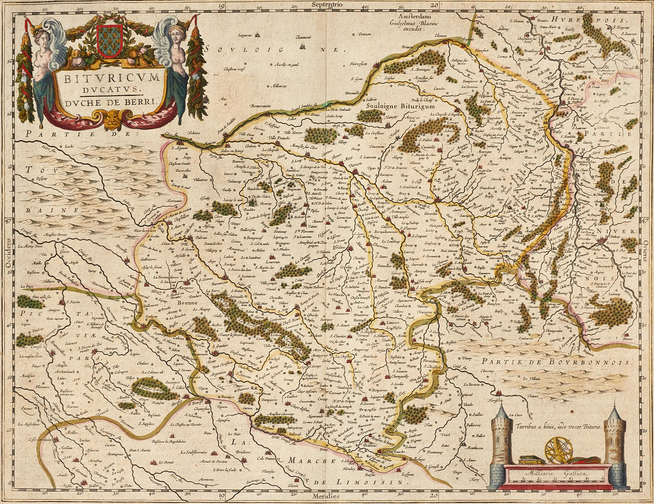
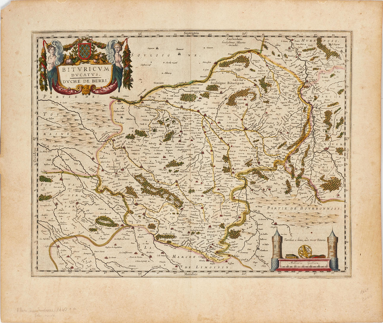
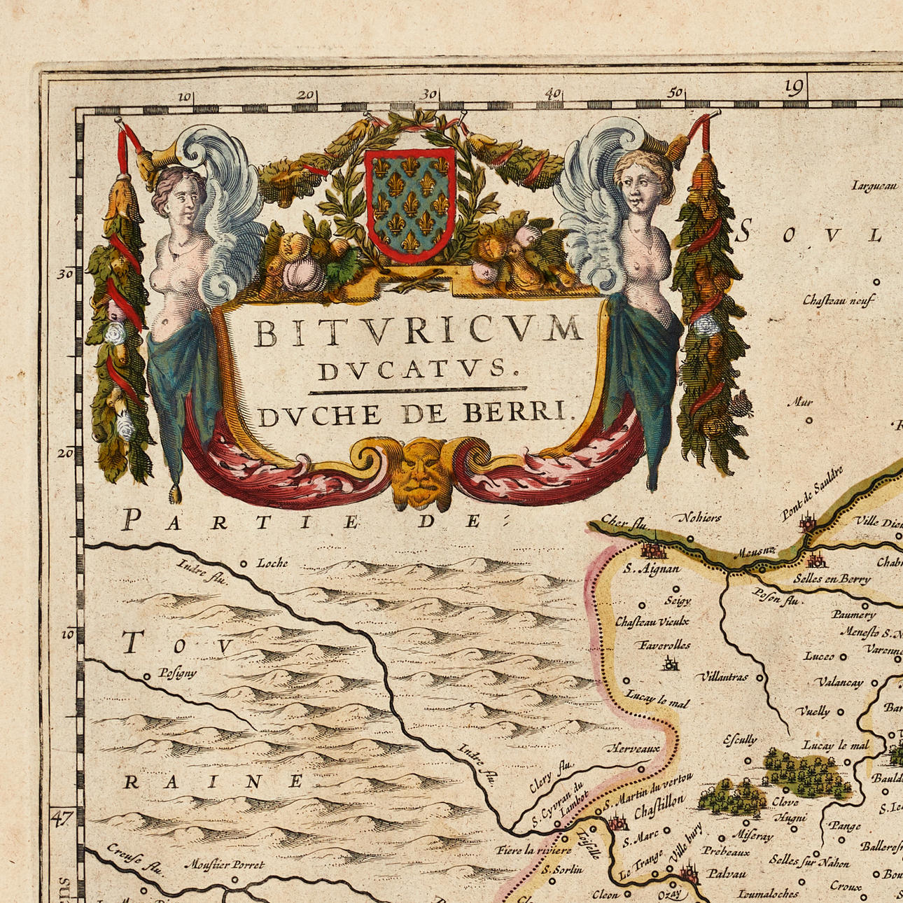
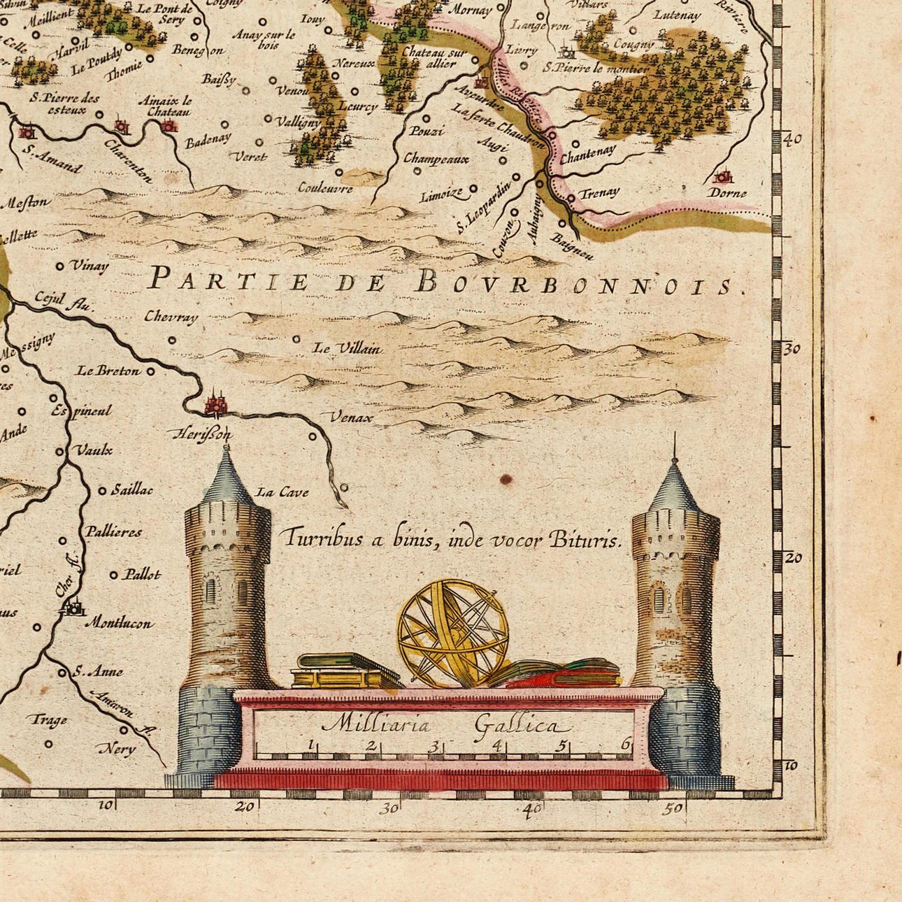
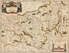
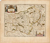
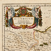
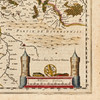
Willem Janszoon Blaeu (1571-1638) / Joan Blaeu (1596-1673), "Bituricum Ducatis. Duche de Berri", engraved and hand-coloured map of the central parts of France, featuring cities such as Bourges and Nevers, from "Theatrum Orbis Terrarum sive Atlas Novus", ca 1640, Latin text.
Plate: 38.2 x 50 cm.
Sheet: 50.5 x 59.3 cm.
The Blaeu family was one of the most successful and renowned cartographers and publishers of maps in Europe during the 17th century.
The father, Willem Janszoon Blaeu (Guilielmus Janssonius, 1571-1638), studied mathematics under Tycho Brahe and learned the theoretical and practical foundations of astronomical observations as well as the art of manufacturing instruments and globes.
In 1596, he settled in Amsterdam as an instrument maker and cartographer. His first cartographic work was a globe in 1599, and he likely published his first printed map in 1604. Blaeu specialized in maritime cartography and was appointed cartographer to the V.O.C. (Verenigde Oostindische Compagnie) in 1633. After publishing books, wall maps, globes, and nautical charts for thirty years, he published his first atlas, Atlas Appendix, in 1630, which marked the beginning of a long tradition of various atlases by the Blaeu family.
In 1618, another cartographer, bookseller, and publisher, Johannes Janssonius, established himself near Blaeu's shop. They became fierce competitors and accused each other of copying and stealing information. Around 1621, Willem Janszoon decided to adopt his grandfather's nickname "blauwe Willem" as a family name to once and for all dispel the confusion surrounding the two competitors' names, henceforth calling himself Willem Janszoon Blaeu.
When Willem Janszoon Blaeu passed away in 1638, his sons Cornelius and Joan (Johannes) inherited the successful business. It is only known that Cornelius's name is mentioned in the prefaces of books and atlases until about 1645.
Joan Blaeu was born in Amsterdam in 1596 and was active in his father's bookstore and printing business. In 1638, he took over the role of cartographer to the V.O.C. His most magnificent and famous works are the Atlas Maior and the works on the cities of the Netherlands and Italy.
A fire devastated the business on February 23, 1672, and a year later, Joan passed away. The fire and Joan's death led to all inventory and quantities of books, atlases, copper plates, globes, and more that remained being sold at five public auctions in Amsterdam. In the following years, the printing business itself remained under the Blaeu family's control until it ceased in 1695, when all inventory was sold at auction. This was the end of the long-standing, magnificent business where Willem Janszoon Blaeu and his son Joan Blaeu were among the most famous and successful map publishers of the 17th century.
Condition
Yellowed. Stains. Moisture stains on the upper edge of the sheet. A few small tears (approx. 4-10 mm) on the edge of the sheet. Upper left corner with creases and paper loss.
Unframed.
Theme
Francesco Bacoccoli Collection - The Golden Era of Cartography: Part II
Description
Willem Janszoon Blaeu (1571-1638) / Joan Blaeu (1596-1673), "Bituricum Ducatis. Duche de Berri", engraved and hand-coloured map of the central parts of France, featuring cities such as Bourges and Nevers, from "Theatrum Orbis Terrarum sive Atlas Novus", ca 1640, Latin text.
Plate: 38.2 x 50 cm.
Sheet: 50.5 x 59.3 cm.
The Blaeu family was one of the most successful and renowned cartographers and publishers of maps in Europe during the 17th century.
The father, Willem Janszoon Blaeu (Guilielmus Janssonius, 1571-1638), studied mathematics under Tycho Brahe and learned the theoretical and practical foundations of astronomical observations as well as the art of manufacturing instruments and globes.
In 1596, he settled in Amsterdam as an instrument maker and cartographer. His first cartographic work was a globe in 1599, and he likely published his first printed map in 1604. Blaeu specialized in maritime cartography and was appointed cartographer to the V.O.C. (Verenigde Oostindische Compagnie) in 1633. After publishing books, wall maps, globes, and nautical charts for thirty years, he published his first atlas, Atlas Appendix, in 1630, which marked the beginning of a long tradition of various atlases by the Blaeu family.
In 1618, another cartographer, bookseller, and publisher, Johannes Janssonius, established himself near Blaeu's shop. They became fierce competitors and accused each other of copying and stealing information. Around 1621, Willem Janszoon decided to adopt his grandfather's nickname "blauwe Willem" as a family name to once and for all dispel the confusion surrounding the two competitors' names, henceforth calling himself Willem Janszoon Blaeu.
When Willem Janszoon Blaeu passed away in 1638, his sons Cornelius and Joan (Johannes) inherited the successful business. It is only known that Cornelius's name is mentioned in the prefaces of books and atlases until about 1645.
Joan Blaeu was born in Amsterdam in 1596 and was active in his father's bookstore and printing business. In 1638, he took over the role of cartographer to the V.O.C. His most magnificent and famous works are the Atlas Maior and the works on the cities of the Netherlands and Italy.
A fire devastated the business on February 23, 1672, and a year later, Joan passed away. The fire and Joan's death led to all inventory and quantities of books, atlases, copper plates, globes, and more that remained being sold at five public auctions in Amsterdam. In the following years, the printing business itself remained under the Blaeu family's control until it ceased in 1695, when all inventory was sold at auction. This was the end of the long-standing, magnificent business where Willem Janszoon Blaeu and his son Joan Blaeu were among the most famous and successful map publishers of the 17th century.
Condition
Yellowed. Stains. Moisture stains on the upper edge of the sheet. A few small tears (approx. 4-10 mm) on the edge of the sheet. Upper left corner with creases and paper loss.
Unframed.
Theme
Francesco Bacoccoli Collection - The Golden Era of Cartography: Part II
Payment options for this item
Payment cardsBank transferDelivery
: Provide your locationInfo temporarily unavailableLoading…Provide your location to see transport options and prices.
Oops! Something went wrong.
Please try again in a moment. If it still doesn't work, contact Auctionet support.
Details
- Address
Galoppvägen 3
183 64 Täby
Sweden- Placement
- Vagga Bacoccoli Stor