JANSSONIUS (Heirs), Tractus Borysthenis, ca 1680.
This auction is closed, but maybe you like the following items?

Images
Description
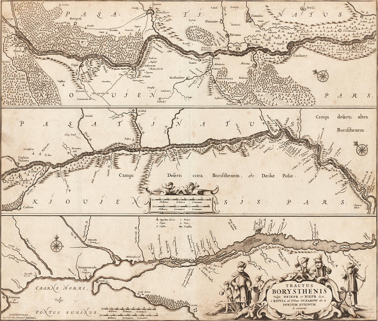
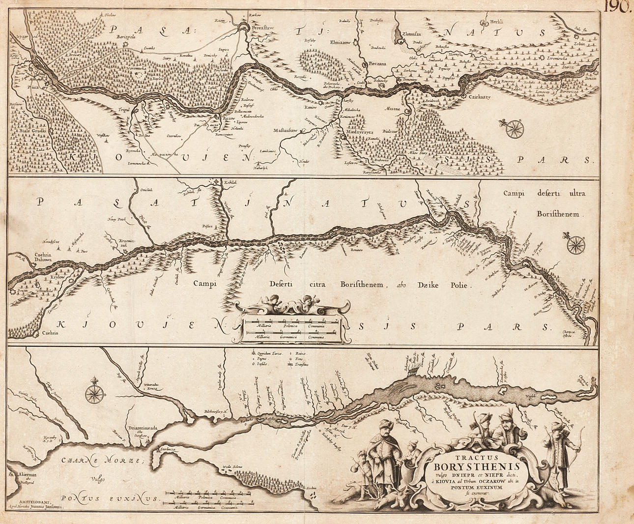
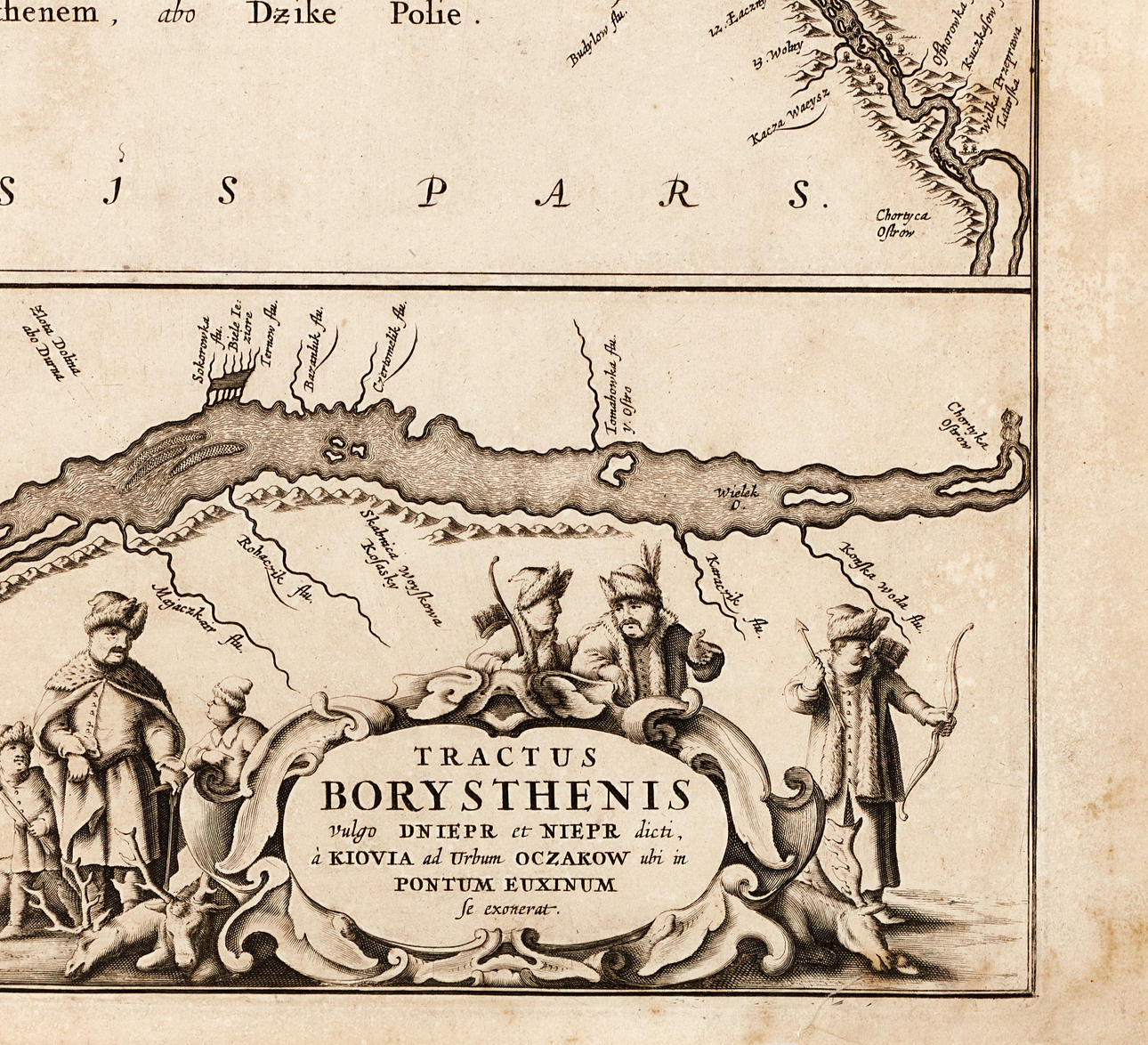
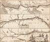
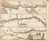
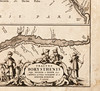
Johannes Janssonius (Heirs), “Tractus Borysthenis vulgo Dniepr et Nier dicte, à Kiovia ad Urbum Oczakow ubi in Pontum Euxinum se exonerat”, engraved map of the Dnieper River, c. 1680 (first published 1656).
Plate: 46.2 x 54.2 cm.
Leaf: approx. 48 x 58 cm.
LITERATURE: Koeman 1760.1.1.
The map shows the course of the Dnieper River from Kiev and up to its outlet into the Black Sea. In the lower right corner a decorative cartouche surrounded by fur-clad hunters with felled prey at their feet. In the middle a cartouche for the scale and two putti with measuring instruments.
Johannes Janssonius (Jansson, 1588-1664) was a contemporary competitor in Amsterdam, the then European centre for the production of maps to the cartographer Willem Janszoon Blaeu. Janssonius' earliest work is a map of France and Italy in 1616. In 1612 he married Elisabeth de Hondt, sister of cartographer Henricus Hondius (1597-1651) and Jodocus Hondius II (1593-1629) with whom he began cohabitation in 1628. The brothers' father Jodocus Hondius I (1563-1612) had around 1604 acquired the copper plates after Mercator and issued a completely revised edition of Mercator's “Atlas” in 1606. Under Janssonius' leadership, Hondius' atlas was constantly expanded. It was given a new title, “Atlas Novus” and consisted of three volumes in 1638 of which one was entirely devoted to Italy. In 1646, the fourth volume was published with maps of England, which was a year after a similar Atlas published by Blaeu. The competitors' maps are reminiscent of each other, and Janssonius is often accused of copying Blaeu but Janssonius's maps are often slightly earlier than Blaue's and sometimes cover different regions. In 1650, “Orbem Maritimus was issued where “Mar del Nort” is one of the 33 maps in the fifth volume. By 1660, the atlas had finally been named “Atlas Maior” and consisted of 11 volumes. Editions were printed in Dutch, Latin, French and a few times in German. Upon the death of Henricus Hondius in 1651, Janssonius took over his business and Janssonius's business was later taken over by Peter Schenk, who republished his “Atlas Maior” around 1683.
Condition
Yellowed, spots. Defects, folds, tears (about 5-10mm, three of which reach the image surface) along the edges/margin of the blade. A repaired tear in the lower right corner (25mm, partly in the picture). The edges unevenly cropped. Inscription in ink (“190") in the upper right corner. In addition to the middle fold, a vertical fold fold in the left part. A hard crease in the lower left part of the image.
Not framed.
Theme
Francesco Bacoccoli Collection - The Golden Era of Cartography: Part I
Do you have something similar to sell? Get your items valued free of charge!
Description
Johannes Janssonius (Heirs), “Tractus Borysthenis vulgo Dniepr et Nier dicte, à Kiovia ad Urbum Oczakow ubi in Pontum Euxinum se exonerat”, engraved map of the Dnieper River, c. 1680 (first published 1656).
Plate: 46.2 x 54.2 cm.
Leaf: approx. 48 x 58 cm.
LITERATURE: Koeman 1760.1.1.
The map shows the course of the Dnieper River from Kiev and up to its outlet into the Black Sea. In the lower right corner a decorative cartouche surrounded by fur-clad hunters with felled prey at their feet. In the middle a cartouche for the scale and two putti with measuring instruments.
Johannes Janssonius (Jansson, 1588-1664) was a contemporary competitor in Amsterdam, the then European centre for the production of maps to the cartographer Willem Janszoon Blaeu. Janssonius' earliest work is a map of France and Italy in 1616. In 1612 he married Elisabeth de Hondt, sister of cartographer Henricus Hondius (1597-1651) and Jodocus Hondius II (1593-1629) with whom he began cohabitation in 1628. The brothers' father Jodocus Hondius I (1563-1612) had around 1604 acquired the copper plates after Mercator and issued a completely revised edition of Mercator's “Atlas” in 1606. Under Janssonius' leadership, Hondius' atlas was constantly expanded. It was given a new title, “Atlas Novus” and consisted of three volumes in 1638 of which one was entirely devoted to Italy. In 1646, the fourth volume was published with maps of England, which was a year after a similar Atlas published by Blaeu. The competitors' maps are reminiscent of each other, and Janssonius is often accused of copying Blaeu but Janssonius's maps are often slightly earlier than Blaue's and sometimes cover different regions. In 1650, “Orbem Maritimus was issued where “Mar del Nort” is one of the 33 maps in the fifth volume. By 1660, the atlas had finally been named “Atlas Maior” and consisted of 11 volumes. Editions were printed in Dutch, Latin, French and a few times in German. Upon the death of Henricus Hondius in 1651, Janssonius took over his business and Janssonius's business was later taken over by Peter Schenk, who republished his “Atlas Maior” around 1683.
Condition
Yellowed, spots. Defects, folds, tears (about 5-10mm, three of which reach the image surface) along the edges/margin of the blade. A repaired tear in the lower right corner (25mm, partly in the picture). The edges unevenly cropped. Inscription in ink (“190") in the upper right corner. In addition to the middle fold, a vertical fold fold in the left part. A hard crease in the lower left part of the image.
Not framed.
Theme
Francesco Bacoccoli Collection - The Golden Era of Cartography: Part I
Do you have something similar to sell? Get your items valued free of charge!